
Defending The Firth Of Forth
During the Second World War the Firth of Forth was a waterway of vital strategic importance to both the Royal Navy and the Merchant Navy alike. The naval dockyards at Rosyth, the docks at Leith and the deep-water anchorages available made the Forth a tempting target for the Luftwaffe. It was no coincidence that some of the first aggressive moves of the Luftwaffe against targets in the UK were made in the Forth. Understandably, therefore, considerable efforts were put into a range of major defensive measures. These included the fortification of a number of the Forth’s islands (e.g. Inchkieth), the provision of three separate lines of coastal batteries and the laying of a number of minefields within the Firth of Forth.
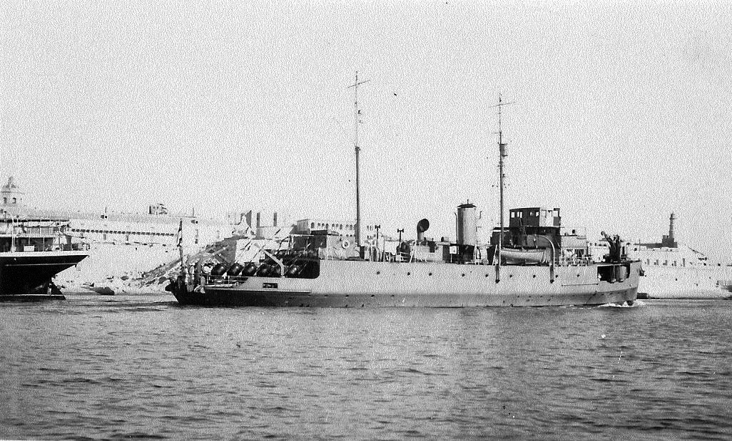
HMS Plover: Minelayer In The Forth.
Minefields
A small defensive minefield was laid at the entrance to the Forth in 1939. In September, 1939, HMS Plover, a coastal minelayer, was employed to lay further minefields off the Bass Rock in Operation BEM. This was added to by Plover again in Operation CP in November. In December, 1939, Plover continued to lay more mines but a Boom defence vessel (Bayonet) sank on the 22nd and some mine-sweeping was required to alter the shape of the field.*
In general, defensive mines were laid along the southern shores of the Firth of Forth, the main channel for shipping lying along the northern shore, and to the north of the Isle of May. These mines were designed to prevent any enemy ships, including submarines, from attempting to enter the Forth and a number could be detonated electronically from an installation on Inchkieth should an enemy vessel be spotted over the minefield.
Similar measures were taken at all the east coast ports and minefields were laid along the length of the North Sea coast of Britain in an effort to protect the east coast shipping lanes.
German Offensive Operations In The Forth
Of course, the Germans were equally determined to lay mines in this important area and extensive mine-laying was carried out by both the German Air and Naval Forces. This involved a combination of Stavanger based bombers and U-boats sailing from both German and Norwegian bases. Submarines, in particular, proved difficult to spot since they were almost invisible to existing radar devices at the start of the war and mine-laying aircraft often flew below the coverage of the radar chain stations, especially when in the actual process of laying their mines. A considerable number of ships were lost in the early months of the war to magnetic mines laid at the entrances to the east coast ports and the Forth was no exception.
HMS Belfast Damaged
At 10.58am on 21 November 1940, the cruiser HMS Belfast, only just over a year into its service life, had its back all but broken by a magnetic mine as it was leaving the Firth of Forth. The mine didn’t break the outside plates but buckled them so badly that Belfast’s keel was severely warped. It wrought further damage on Belfast’s engine and boiler rooms and injured twenty-one of its crew. A tug, the Krooman, turned from towing gunnery targets and instead towed Belfast to Rosyth for initial repairs. Once Belfast was deemed to be seaworthy, it was taken to Devonport where it was virtually rebuilt. Should one visit the Belfast in London today, one can still trip over an unexpected surface bulge on its deck, a reminder of its close shave in the Firth of Forth and evidence of where the ship required additional strengthening as result of its mining.
The desperate threat of the magnetic mine in 1939 and 1940 was eventually beaten when one was rendered harmless by two bomb disposal experts and its method of operation discovered. However, the Germans continued to drop mines in the Forth area, although not all of them landed in the estuary. A number were dropped over land, for example, near Traprain Law.
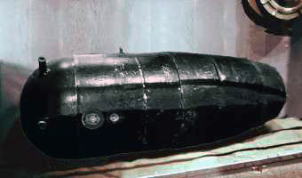
An early German magnetic mine of the type
(mk 1 Type GA) which damaged HMS Belfast.
Source - Pete Goodeve.
Mines On Land!
On 24 July 1940, two mines landed on the west end of Traprain Law, dropped there by an aircraft which had been intercepted by a night fighter. It's pure conjecture but it may also have been a mine-laying aircraft which, having laid its mines in the Forth, dropped its supplementary load of bombs on Haddington on 3 March 1941.
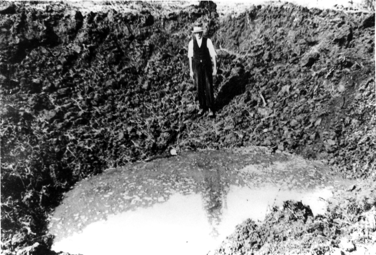
J. Rutherford, Road Foreman, standing in the one
of the Traprain mine craters, twenty-five feet
across and fifteen feet deep.
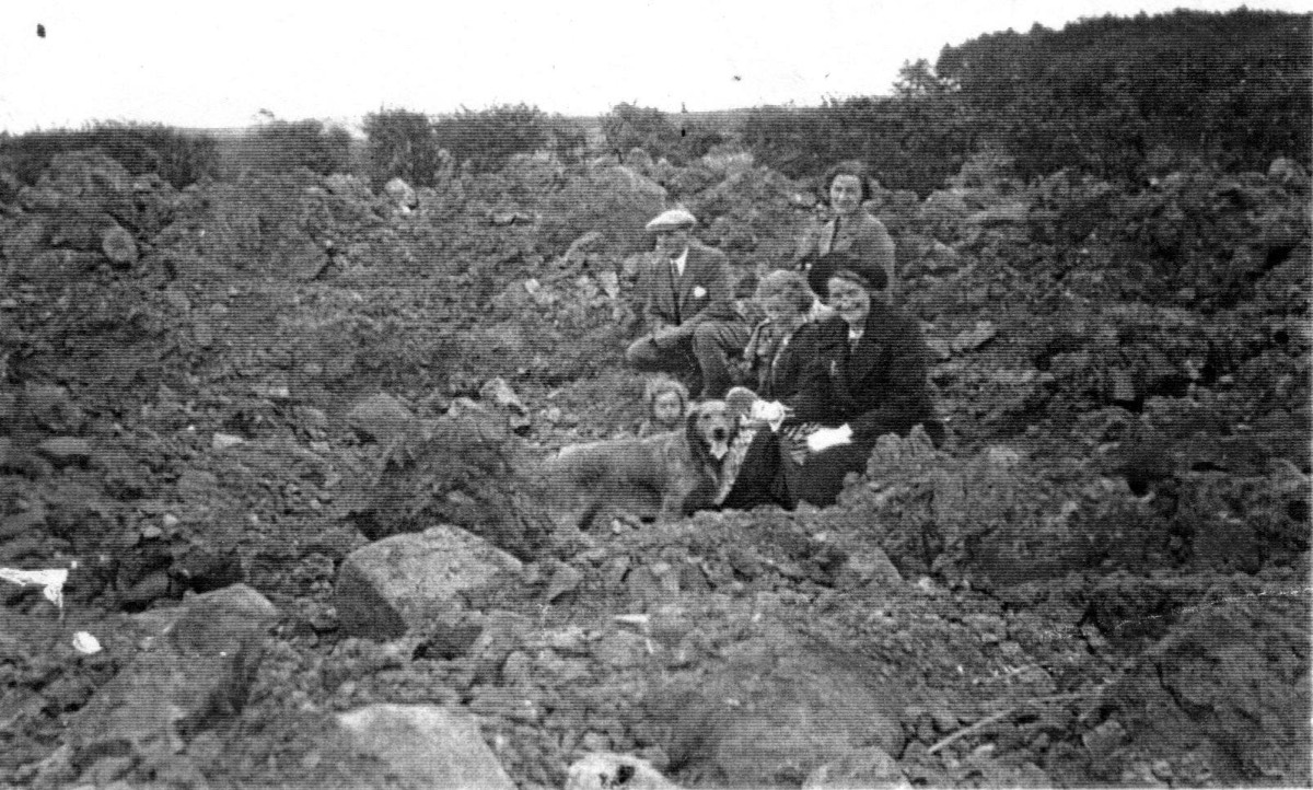
Local plumber Robin Ross and his family sitting
in the second Traprain mine crater.
Fidra Radar Station
It was, however, essential to ensure that the British-laid minefields were not a hazard to friendly shipping. Consequently the Royal Navy set up a radar station on the coat just north of Dirleton. This station had no connection with the RAF’s Ground Control of Interception station at Dirleton and lay a little to the north of it. Nor did it have any direct connection with Fidra coastal artillery battery which lay nearby. The Naval station, known officially as Fidra, even though it was not built on the island, mounted a Type 273 radar which operated on the very short wavelength of ten centimetres. This gave the station a tremendous degree of accuracy enabling it to guide ships between the minefields without danger.
Fidra radar station was, however, not well sited. Its location on the mainland just opposite the island meant that much of the radar display was filled with returns from Fidra island itself, thereby reducing the efficiency of the radar equipment. As a result of these problems, the station closed down within a few months of becoming operational.
Indicator Loop System
Another measure taken by the Royal Navy for the protection of the Firth of Forth was the installation of an Indicator Loop System. This comprised two sets of electric cables, laid on the seabed of the estuary about a mile apart. Whenever any large metal object, such as a ship, passed over the cables, the ship’s magnetic field would create a response in the cables which would be detected by the sensitive equipment. There being two separate cables, it was possible to determine the direction in which the ship was moving.
If prior notification of the passage of a ship had not been received, it was possible that there was an enemy ship or submarine attempting to enter, and the defences could be alerted accordingly. In many cases, when Royal Navy ships were sent to investigate, it was found that the vessel was a fishing boat which had failed to notify the authorities of its movements. The indicator loop system in the Forth was controlled from the Isle of May, the southern loop running from there to Canty Bay, near Tantallon. Another loop ran north from the island to the Fife coast, thereby covering the whole of the estuary.
Conclusion
It can be seen from the above that an extensive network of defences, manned by a significant number of military personnel, guarded the Firth of Forth during the Second World War. Thanks to this combination of minefields, coastal artillery, indicator loops, naval vessels and air defences, no German ships ever attempted to enter the Forth to attack Rosyth. That alone justified the effort involved in creating and manning these complex defences.
* My thanks to Gordon Smith (www.naval-history.net) for this information and for the photograph of HMS Plover.